Research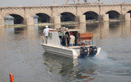
|
The shortest definition for hydrographic survey is surveying water bodies. It deals with the measurement of physical characteristics of surface and subsurface water bodies, i.e. boundaries (X, Y coordinates) depth (Z coordinate), surface level (Z coordinate) as well as other measurements like flow velocity, sampling of river bed and suspended sediment materials. As it is important to be aware of the fact that, the quality of any study is only as good as the quality of the information gained through the data collected, and the influence of any error incurred during the measurements leads to limiting the accuracy of the study, a highly trained researchers and technicians equipped by up to date surveying equipments are responsible for the data collection. HRI developed surveying system that proofed high quality performance. Major elements of hydrographic survey:Field measurement campaign, hydrographic survey consists of three phases: Design:In the design phase, maps, aerial photographs and other pieces of information (e.g. results of previous campaigns) are used to define where and how the measurements will take place. It is always useful to have an inspection of the area to have the most up-to-date insight into the circumstances, to minimise the unforeseeable difficulties. The output of this phase is a measurement plan in forms of charts, time planning, personnel and budget estimates. Field work:
During the field work, the following measurements are taken and documented: Data Analysis, Processing and Quality Checks:
After the data has been collected from the site the data processing stage then started to produce a day by day dataset in the form of: |